
 Dartmoor National Park comprises 368 square miles of open moorland, high granite tors, forest, farmland and river valleys in Devon. 34,000 people live and work within the park boundaries and it welcomes around 2.4 million visitors a year. As the statutory body responsible for management of the park, Dartmoor National Park Authority have a responsibility to conserve and enhance the natural beauty, wildlife and cultural heritage of the area and have direct maintenance responsibility for a number of buildings, locations and associated fixed assets within the park boundaries.
A key part of this responsibility is maintaining a public rights of way (PROW) network comprising nearly 500 miles of footpaths, bridleways and byways across an area of 368 square miles. This network contains well over 6000 items of associated infrastructure including gates, stiles, bridges, signs and way-markers, all of which need to be surveyed on a two-yearly cycle. As well as assessing the condition of rights of way “furniture”, the surveys also involve recording any issues relating to the linear routes including obstructions, poor surfaces, drainage issues and erosion.
The Challenge
Previously, the surveys were undertaken using paper forms, which once completed had to be manually transcribed into the park’s IT and mapping systems. There was also no easy way of confirming location details, reconciling photos of the assets with inspections records, and the paper sheets often fell victim to the notorious Dartmoor weather!
 Having successfully worked with Dartmoor National Park for several years on previous projects to digitise maintenance forms and provide a general mobile asset and work management solution, Arcspeed were asked in 2019 to develop proposals to deliver a PROW survey capability via our Mobile Asset Management app.
The Solution
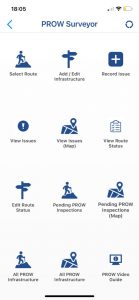
Adopting an agile approach, we worked closely with DNPA’s Recreation, Access & Estates team to capture the key requirements and developed an intuitive, flexible and fully mobile survey app. Alongside this we also delivered a cloud-hosted database back-end along with extensions to the existing web portal to allow office-based staff to easily view and access inspection data and maintain reference data.
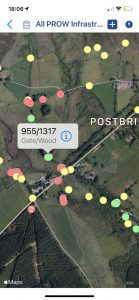
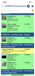
The mobile app element contains a list of the infrastructure associated with each route within the park, which can be viewed on an interactive map as the user walks the route, enabling the surveyor to easily see where they are in relation to nearby route “furniture”.
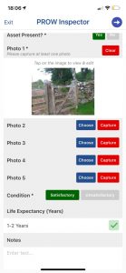
Selecting an item from the map opens a detailed view against which the surveyor can record condition data, capture photos of any defects and confirm the location using GPS on the device. The app can also be used to record new or changed infrastructure along with any spot issues associated with the right of way itself – for example poor surface, erosion, vegetation, fallen trees, blocked access etc
Offline Working
 The ability for the app to work offline was a crucial requirement since many parts of Dartmoor have very poor 4G coverage. In such areas, any data collected via the app is cached on the device and uploaded automatically once a WiFi or mobile data signal is reacquired.
How the Information is Used
The condition data captured via the app is automatically uploaded to the cloud-hosted database. This database is fronted by a web portal which enables managers and office-based staff to get a live view of the surveys as they are completed, monitor progress of the overall activity through a summary “dashboard”, schedule future inspections and also maintain all associated reference data. The survey data can also be easily exported from the web portal in a format which can be uploaded to DNPA’s Countryside Access Management (CAMS) mapping system.
The inspection data captured via the surveys is vital in highlighting any immediate safety or accessibility issues, planning and prioritising future investment and also potentially informing the allocation of grants under DEFRA’s new “Farming in Protected Landscapes” scheme.
Plans for the rollout of the new PROW inspection process were unfortunately put on hold due to the Covid-19 pandemic, however the recent relaxation of restrictions have allowed this to resume, with plans now in place for trained volunteer wardens to complete a full survey of the route infrastructure by the end of 2022.
Interested in Learning More?
 As a company based on Dartmoor, Arcspeed are proud to continue working with our much-loved local National Park, and delighted to see our technology solutions being used to make a real difference in maintaining and protecting this beautiful, vitally important and iconic landscape.
Click here to find out more about our Mobile Asset Management app or alternatively contact us for further information or to arrange a free consultation on how our suite of asset management solutions can help your organisation.
Although Dartmoor National Park Authority are not currently recruiting voluntary wardens, there are other ways to volunteer, which you can find out about on their Jobs and Volunteering page.
The Authority also welcomes feedback and reports from the public which can be submitted online via their Report a Path page.
Tim Russell
Very useful & interesting article. Many thanks to the Arcspeed Team (Jon & Jake) for an excellent PRoW Asset Management training event for our Voluntary Wardens.
Much appreciated.
Tim Russell
Recreation & Access Projects Officer
Dartmoor National Park Authority
arcspeed
You’re very welcome Tim. It was fab to work with such an enthusiastic and knowledgeable group. Thank you, and all the best.
Moray Bowater
This sounds excellent and a huge step forward for DNPs management of rights of way. The value of footpaths to the community and visitors should not be underestimated. They are a very valuable and uniquely British asset. Congratulations on this work.
arcspeed
Thanks Moray – we’re really proud of our work on this project. It’s a great example of how technology can be used to facilitate volunteers being engaged to carry out important survey work. As it stands well over 45% of the rights of way network due to be surveyed on Dartmoor has been completed using the app and it’s capturing vital information about the condition of the infrastructure.
Teign
Not only is this a very good project but it’s really good to see Dartmoor NPA looking for and investing in local tech resources to fulfill their needs. Well done.
arcspeed
Thanks Stephen. It’s been a really interesting local project to be involved in and – we hope – a case study that can be applied elsewhere given the pressures that rights of way are under across the country. They are such a key asset – both for rural communities and nationally.
Protected: Showing the Way – Supporting Fingerpost Renewals in Dartmoor National Park - Arcspeed Digital Solutions Ltd
[…] Surveying Dartmoor’s Rights of Way – 15/07/2021 […]